Saturday Evening, February 15
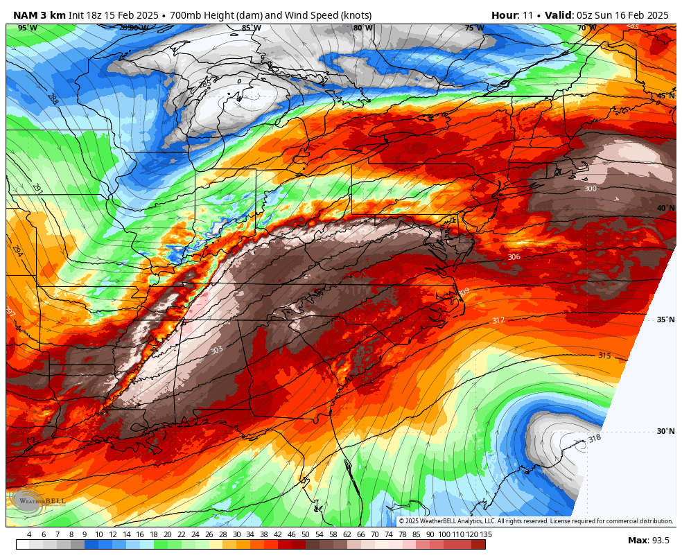
The unexpected surge of snow and sleet today proved to be quite intense. I jokingly referred to it as an overachiever since its strength overwhelmed the warm pavement, creating slick roads that resulted in numerous accidents. Upon reflection, I noticed that the NAM 3 Km Model had accurately forecasted conditions better yesterday than it did this morning.
This observation is important as I plan to focus on this model while analyzing the next phase of the storm expected on Sunday.
While there’s considerable interest in the larger snowstorm forecast for next week, I want to highlight the effects of the current weather event.
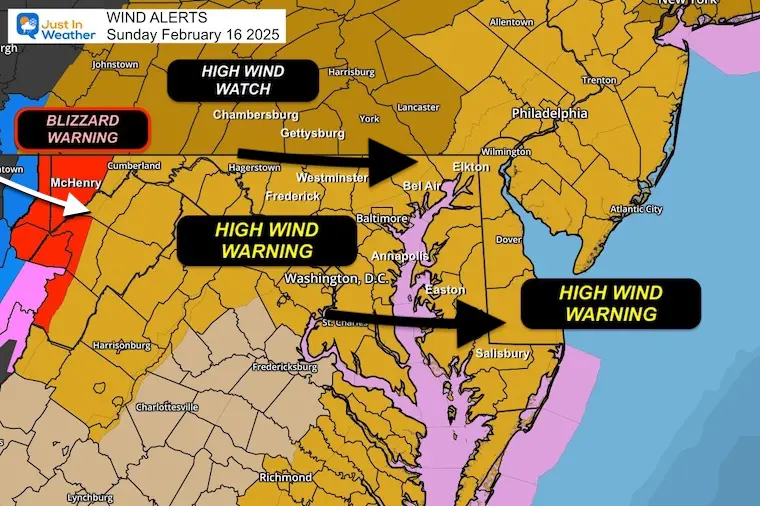
Storm Alerts
Blizzard Warning:
For the High Mountains, including Garrett County, MD.
- Monday, 1 PM to 3 PM: Anticipate 4 to 8 inches of snow along with wind gusts between 55 to 65 mph.
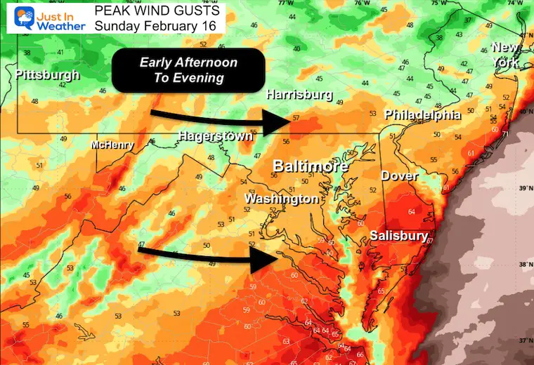
High Wind Warning: 10 AM to 10 PM
- Regions in Central Maryland and Delaware: Expect wind gusts of 50 to 60 mph.
High Wind Watch:
- Counties in Pennsylvania awaiting an upgrade from the NWS State College office.
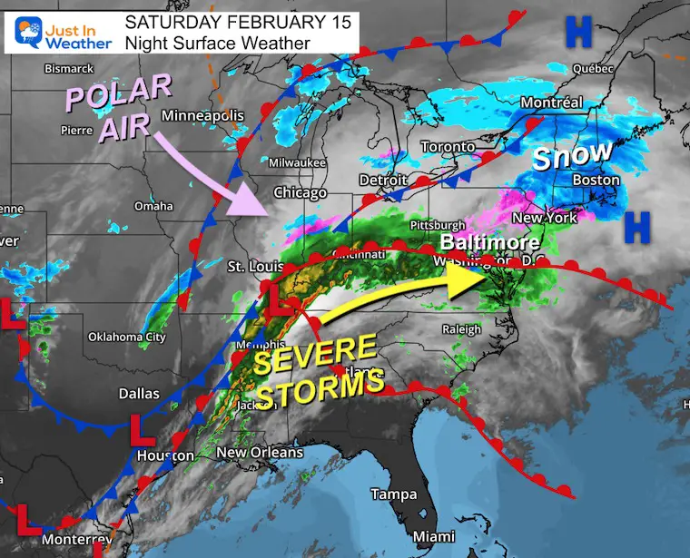
Saturday Evening Setup
This powerful storm has brought severe weather and flooding to the Tennessee River Valley.
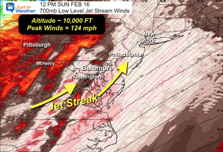
Low-Level Jet Stream: 12 AM Sun to 12 AM Mon
700mb: Altitude of 10,000 Ft
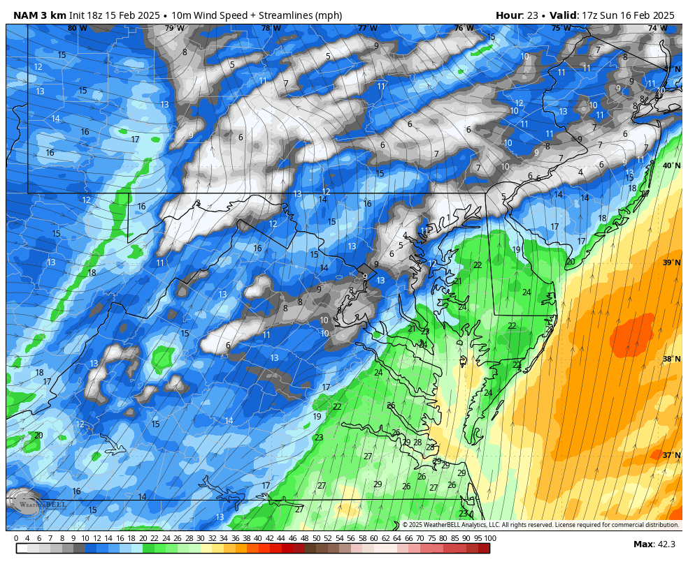
The forecasted low-level jet will reach speeds over 100 mph above Central Maryland around noon on Sunday.
12 PM Sunday
The low-level jet could impact Virginia and Maryland at speeds potentially reaching 124 mph. This will intensify the line of thunderstorms and allow winds to approach closer to the surface as cold air moves in.
Surface Wind Forecast: Noon to Midnight
Peak Wind Gusts
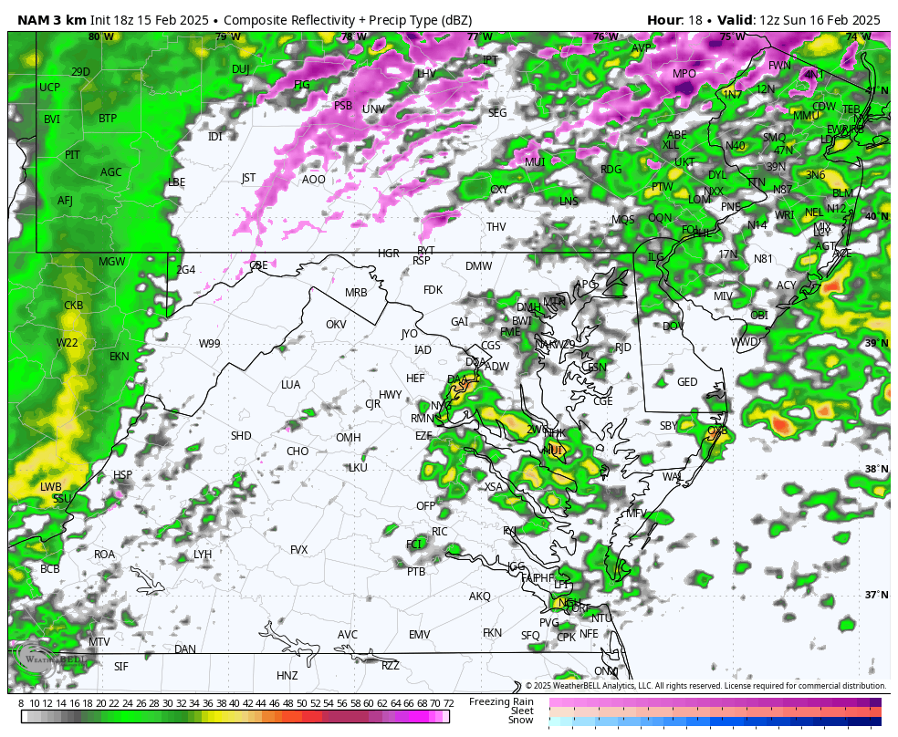
Radar Simulation: 7 AM Sun to Midnight
Morning showers may subside as warm air surges in, fueling a developing line of heavy rain and thunderstorms by late morning to early afternoon.
The subsequent cold winds will trigger a Lake Effect Snow Event for the mountainous regions of Western Maryland.
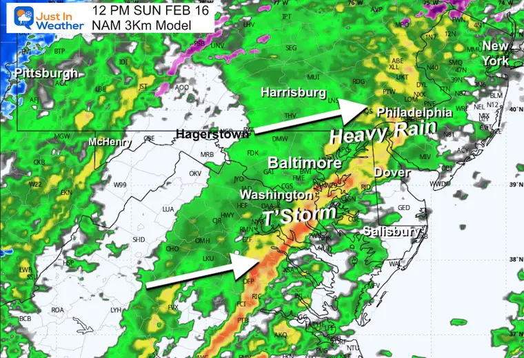
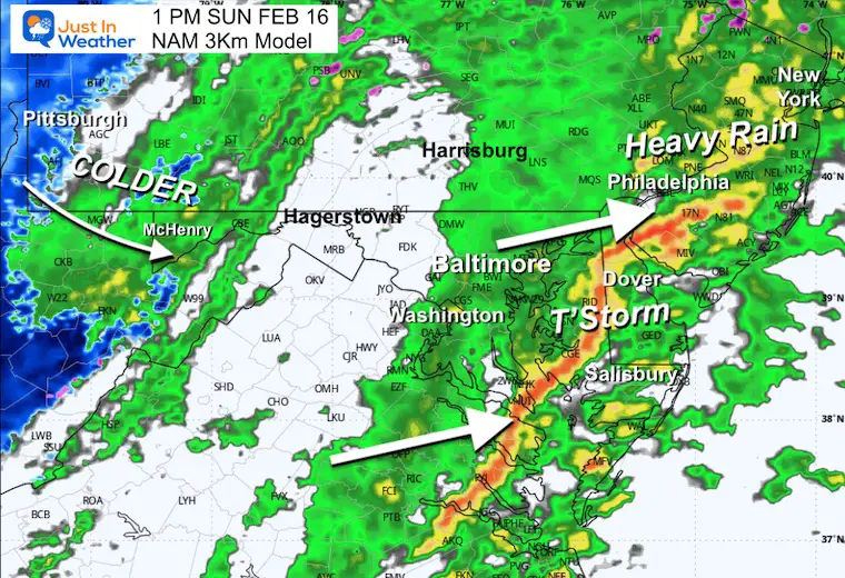
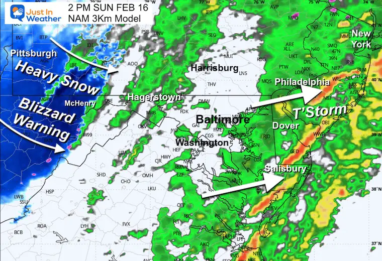
Forecast Snapshots
11 AM
Developing thunderstorms and showers will be underway.
12 PM
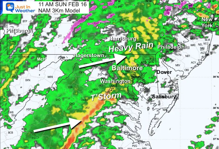
The intense line of rain and thunderstorms is expected to be stronger south of Baltimore.
1 PM
The storm line will cross the Bay into Delmarva.
2 PM
As the storm approaches the coastline, snow will begin to accumulate in the mountains.
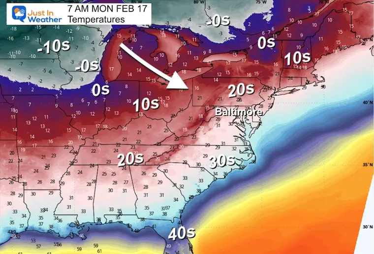
Cold air will surge in, spreading eastwards overnight into Monday morning.
Cold Air Approaching
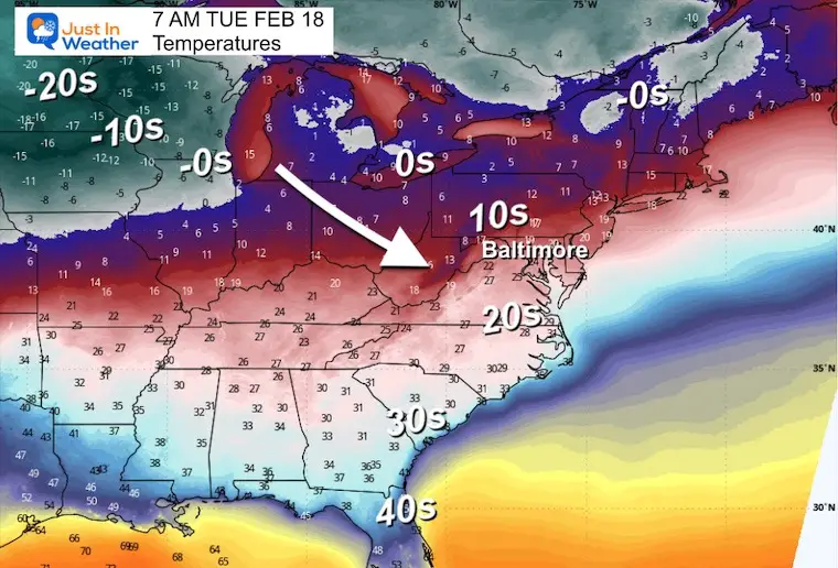
Monday Morning
Tuesday Morning
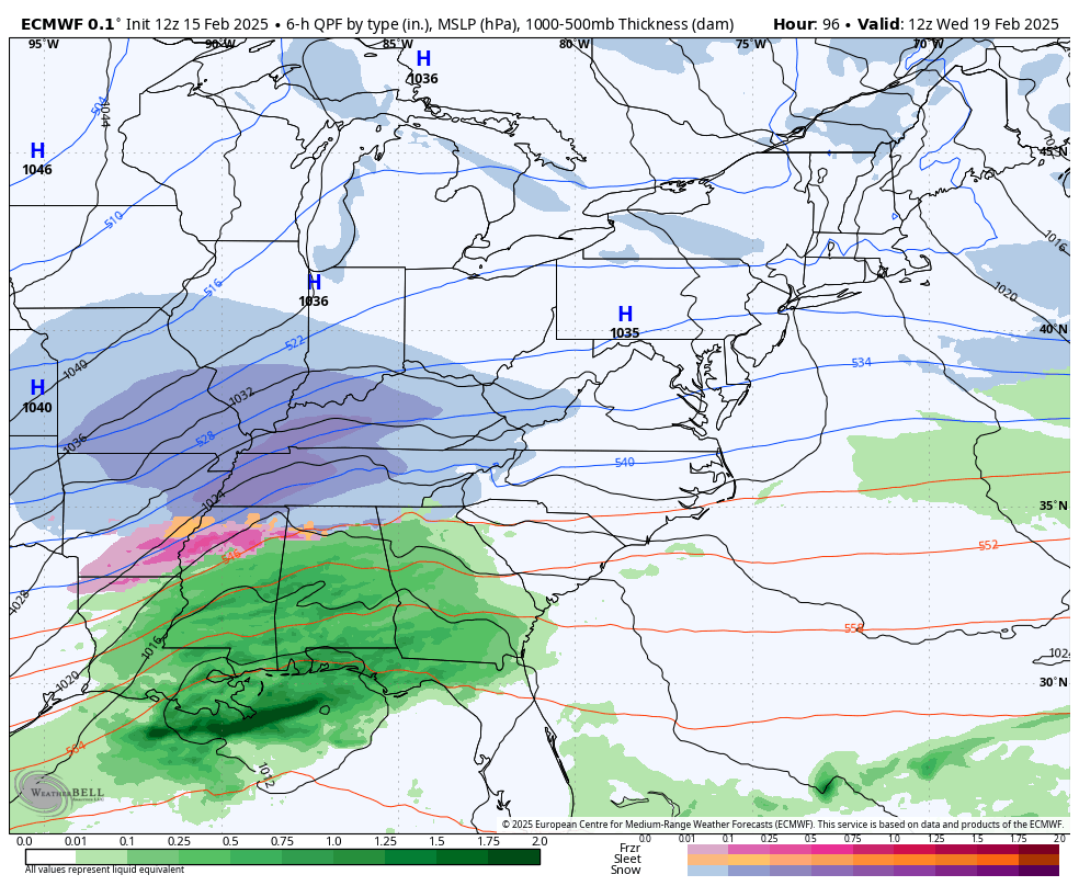
Storm Forecast: From Wednesday Morning to Friday Morning
Below is the latest ECMWF Model run as of Saturday morning.
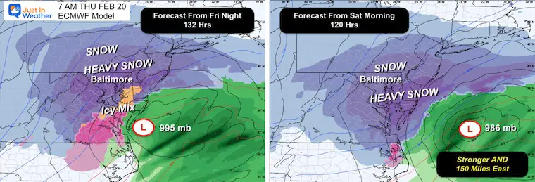
Possible Storm Adjustments?
There has been some adjustments within the computer models, and with five days remaining until the event, I anticipate more updates. I remain optimistic.
I observed that the energy within the jet stream appeared slightly flatter during earlier rain observations.
Despite this, we are still looking at a potential snowstorm — indeed, a more powerful low pressure system. The comparison shows a shift about 150 miles further east for Thursday morning.
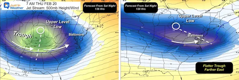
Jet Stream Alterations
The primary factor behind these changes has been observed in the jet stream. Analysis at 18,000 feet indicates a shallower trough in the latest projections, which may result in the storm remaining strong without the typical northeast coast turn. This is simply an upper-level aspect of the weather pattern, and I will continue monitoring for more trends or this could just be a temporary variation.
Snow Totals Forecast?
If you’ve been checking various sources, you may have seen snowfall predictions that appear to have been scaled back. This highlights why I refrain from sharing snow totals that are over three days ahead of time.
For special scenarios, I can present projections that feature the likelihood of at least six inches of snow. As soon as the probability reaches 50%, I’m more inclined to share that projection, as I have done here.
However, I don’t intend to provide a total snowfall range until we acquire more consistent data. This clarity won’t emerge until Monday when the storm’s energy interacts with the grid. This includes the weather balloons monitoring conditions over the Pacific Northwest to gather precise data on what is moving towards us.
Tracking Models
When reviewing models, I must stress that I only consider the 00Z (7 PM) and 12Z (7 AM) runs when we are more than 48 hours from a storm.
The 06Z and 18Z model runs typically lack a complete dataset because they do not include standard weather balloon data.
Consequently, these models may exhibit inconsistencies or sudden changes.
What I will focus on in the next two runs is whether this pattern holds, begins trending eastward, or reverts to the previous model setup.
Since we are still five days away from the potential storm, expect to see some fluctuations.
Stay tuned for updates on the winter weather!
Subscribe for Email Alerts
Receive weather updates directly to your inbox
Sign up to stay informed!
Receive weather updates directly to your inbox
Sign up to stay informed!
Current Snow Reports for This Season
Click on the respective maps for the full reports.
February 11 Snow Report and Assessment of My Forecast
Click here or on the map for more details

January 19 Snow Report

January 11 Snow Report

January 6 Snow Report

Previous Snow Events
November 22 Snow Report

ALSO SEE
Recent Snow Reports
La Nina Advisory January 2025

MY WINTER OUTLOOK

FITF Apparel on Sale

In Case You Missed It
The Story Behind Faith In The Flakes from December 5

Connect with Me and Share Your Weather Photos/Videos
SCHEDULE A WEATHER-BASED STEM ASSEMBLY
Our sessions on Severe Weather: Storm Smart in October and the Winter Weather FITF (Faith in the Flakes) from November to March. Learn more and make a request for your school.

THANK YOU:
Readers’ Choice Awards from Baltimore Magazine
Baltimore Trek: Day 7 Completed on August 10
We raised OVER $104,000 for Just In Power Kids – with more still coming
This annual event covers hiking and biking 329 miles in 7 days from the Summit of Wisp to Ocean City.
Each day, we honor a child and their family’s journey through cancer.
Fundraising is directed towards Just In Power Kids: Providing Free Holistic Programs. I personally do not take any salary; all funds go towards our nonprofit’s mission.
Click here or on the image to donate:

Message on Dyslexia
I acknowledge that there may be spelling and grammatical errors, along with other occasional glitches. I take accountability for my mistakes, including those that may get overlooked by spell-check. I discovered I had dyslexia in my second year at Cornell University, but it didn’t prevent me from completing my meteorology degree, nor from becoming the first in the Baltimore/Washington region to earn the AMS CBM. A professor once told me that I had achieved so much without knowing it, and to not let it hinder my future. That was Mark Wysocki, and he was absolutely right! I also make forecasting errors; no one can perfectly predict the future. All the maps and data provided are accurate, but the wording can be tricky. There’s no one available to review my work while I’m writing it to ensure timely dissemination of information. Barbara Werner is part of the web team and helps me maintain this site. She often edits any errors when possible, which may occur after you’ve seen this. I embrace this, as it demonstrates that what you read truly comes from me… it’s part of my unique charm. #FITF
This rewrite maintains coherence, readability, and a natural flow while ensuring SEO friendliness by using synonyms and varied phrasing without straying from the original meaning.