
Winter Weather Alert for Central New York: Expect Dangerous Conditions
Syracuse, N.Y. – The region is bracing for a hazardous mix of strong gusty winds and concentrated lake-effect snow, which could result in power outages and potentially create near blizzard or whiteout conditions across parts of Central New York until Monday night. Following yesterday’s heavy icing on tree branches, it won’t take much wind to cause large limbs to break. These fallen branches could crash onto power lines, affecting our neighbors’ electricity supply. This situation is particularly concerning as we are in the heart of winter with temperatures significantly below average.
Compounding the issue, there is a substantial threat of heavy snowfall streaming off Lake Ontario, propelled by a west-to-northwest wind flow. The combination of these strong winds and heavy snow will drastically reduce visibility and pose challenges for road crews striving to keep the roads clear.
Current Weather Alerts
Stay informed about the local weather conditions as the position and intensity of lake-effect snow can frequently change.
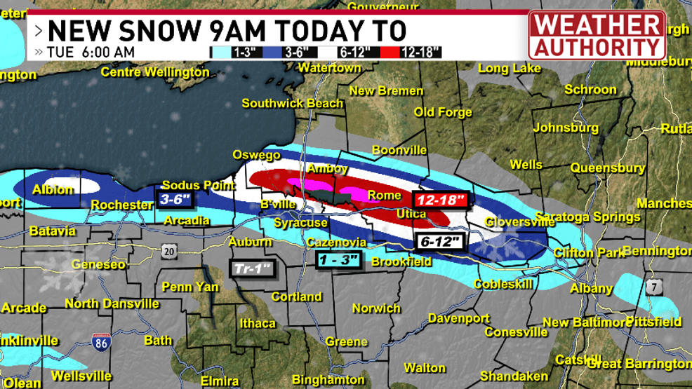
Forecasted Snow Accumulation
From 9 AM Monday to 6 AM Tuesday, expect significant new snowfall. Further accumulation is anticipated from 6 AM Tuesday to 6 AM Wednesday.
For comprehensive details on this intense weather system and to view your 7-day forecast, please explore the resources below.
Stay updated: For the latest weather forecasts, visit our Weather Authority page by clicking here.
Make sure to monitor the situation closely as it develops!