
Let’s take a brief look at the recent adjustments to winter storm forecasts. These updates have emerged due to the latest weather data received overnight.
The alterations are quite minor but indicate a potential increase in snowfall over a marginally larger region of Lower Michigan.
The primary modification involves a slight dip in temperature across all models. To visualize this temperature shift, we can examine the revised position of the snow-to-freezing rain line. Initially, it was expected to pass through southeastern Lower Michigan near Ann Arbor and Detroit. However, the latest model updates have shifted this boundary approximately 20 miles further southeast. As a result, Ann Arbor and most of Detroit are likely to experience more snow with little to no freezing rain. There’s still a chance of a brief period of freezing rain mixed with snow on the southern side of Detroit and in Monroe.

Radar forecast at 6 p.m. Wednesday, February 12, illustrating the freezing rain in pink at the southeastern tip of Lower Michigan.NOAA
For the rest of Michigan, it appears that this storm will predominantly bring snow.
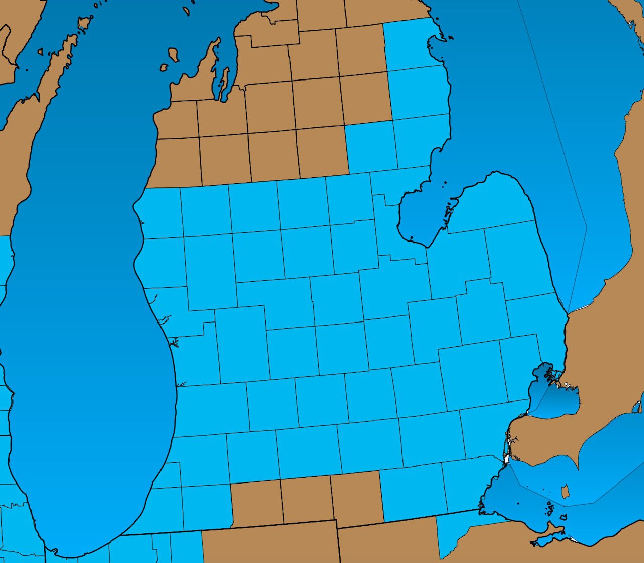
This marginally cooler forecast has prompted updates to the winter storm watch, which various National Weather Service offices in Lower Michigan (Detroit, Grand Rapids, and Gaylord) have expanded to include additional counties.
As of 4:30 a.m. today, February 11, 2025, here is the current status of the winter storm watch.

Winter Storm Watch for blue shaded counties, updated as of 4:30 a.m. February 11. This advisory is in effect from 1 p.m. Wednesday, February 12.NOAA
The winter storm watch now includes four counties in the far southeast of Lower Michigan: Washtenaw, Wayne, Lenawee, and Monroe. The National Weather Service in Detroit made this adjustment in response to the expectation of less mixed precipitation and more snowfall. The watch indicates the period of heavy winter precipitation anticipated from 1 p.m. Wednesday to 7 a.m. Thursday. Consequently, Ann Arbor, Detroit, and Monroe are expected to receive between 4 to 7 inches of snow with just a light glaze of freezing rain.
The Grand Rapids National Weather Service office has also added a few more counties—Calhoun and Jackson—to the winter storm watch due to the colder temperatures that may result in an additional inch or two of snow. As a result, both Jackson and Battle Creek are now expected to receive between 5 to 7 inches of snow by 7 a.m. Thursday.
The Gaylord office of the National Weather Service has included several counties along the northeast shoreline in the winter storm watch. This expansion is based on the colder forecast, which is likely to enhance snowfall in these areas due to Lake Huron’s influence with a northeast wind. Counties such as Alpena, Alcona, Ogemaw, Iosco, Gladwin, and Arenac are now expected to receive between 4 to 8 inches of snow by Thursday morning.
From Grand Rapids to Mount Pleasant and southward, the forecast suggests a snowstorm with totals of 5 to 8 inches. Grand Rapids will likely be situated on the northern fringe of this snowfall, possibly receiving amounts at the lower end of the spectrum.
An update from the Grand Rapids National Weather Service has provided additional insights this early morning. Their 2:30 a.m. discussion notes that widespread snowfall of 4 to 7 inches is anticipated, with a potential band of heavier snow between 7 to 12 inches developing just south of a line extending from Mount Pleasant to Grand Rapids. This phenomenon, known as an FGEN band, indicates a narrow area of intensified snowfall often seen in mature winter storms, typically spanning about 10 miles.
It’s important to remember that accumulating one foot of snow is quite rare in Michigan, even though the state is known for its snowfall. While unusual, it can happen occasionally. The potential FGEN band may lead to localized totals nearing 9 to 10 inches.
However, most residents should expect to shovel around 5 to 7 inches of snow by Thursday morning.
The timeline remains unchanged, with snow expected to begin Wednesday afternoon, peaking in intensity during the evening, and tapering off around sunrise on Thursday.
Stay tuned for further updates and detailed snowfall forecasts here as the storm approaches.