
CNN —
A chain of back-to-back winter storms has begun this week, affecting a vast 1,500-mile area across the eastern United States with snow, ice, and rain as of Tuesday morning.
Following the initial storm, a second winter storm is expected to sweep through many of the same regions, potentially delivering the season’s heaviest snowfall to Chicago. Meanwhile, Southern California will face a significant flooding risk, marking the most severe threat since the devastating wildfires encountered earlier this January.
These storms are part of an ongoing sequence of disruptive weather patterns that have persisted since February began.
Here’s what you need to know:
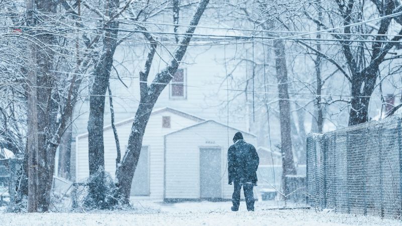
• Snow accumulations are on the way: Snowfall has already begun in areas of the Tennessee Valley and the Appalachians, with 1 to 3 inches recorded Tuesday morning. As the storm moves eastward, regions like Washington, DC, could see up to 6 inches of snow, potentially complicating afternoon travel.
• Emergency declarations and school closures: Virginia Governor Glenn Youngkin has declared a state of emergency, advising residents to refrain from using roads once the storm arrives. Numerous schools in Virginia have closed, while early dismissals are also affecting schools in DC, Maryland, Kentucky, North Carolina, Ohio, and Indiana due to expected weather disruptions.
• Power outages and hazardous travel: Significant ice accumulation, exceeding 0.25 inches, is forecast for parts of West Virginia, Virginia, and North Carolina through Wednesday. The National Weather Service has warned that icy conditions could render many roads dangerous and impassable, potentially causing widespread power outages due to downed tree limbs and power lines.
This latest system is targeting areas further south than previous storms, putting regions that previously escaped winter weather in the path of heavy precipitation.
A swath of snow is predicted north of the Appalachians, where the worst ice impacts are expected. Heavy snowfall will accumulate rapidly in certain locations, including Washington, DC. The city has already received as much snow since December 1 as it typically would over two winters combined.
Snow will also blanket sections of Pennsylvania, New Jersey, and southern New England, with New York City anticipating 1 to 2 inches of new snowfall.
Areas to the south of these winter conditions will experience heavy rain. A significant flood risk persists across the southern U.S. until Wednesday, with a level 2 out of 4 risk affecting Texas through the Carolinas, particularly in regions still recovering from the devastation of Hurricane Helene.
Upcoming Storm Details: Wednesday and Thursday
The next storm will develop in the central U.S. while the initial storm continues to impact the East and rain saturates the South. Snow, ice, and rain are forecast to hit the Plains overnight Tuesday into Wednesday morning.
Kansas Governor Laura Kelly declared a state of disaster on Sunday in response to the looming storm.
By Wednesday evening, this wintry weather will quickly expand across the Midwest and parts of the Northeast.
The bulk of the storm is expected to reach the East Coast by Thursday morning, with snow and ice covering the regions while rain falls farther south. Some areas may only have a brief interlude before the second storm arrives.
Snow accumulation will be heaviest in the Plains and Midwest, with Kansas City, Missouri, potentially seeing close to a foot of snow on Wednesday—almost double the city’s usual total for February.
Chicago could also experience double-digit snowfalls that would mark the city’s largest accumulation this season, having received just over 7 inches since December when typical totals approach two feet.
Icy conditions will again pose a significant threat, primarily in areas just south of the heaviest snowfall zones. A light layer of ice could make travel difficult from Oklahoma and Kansas through the Ohio Valley and Northeast.
Parts of the Appalachians will also face another round of icy precipitation. Residents in locations impacted by the first storm might not experience a pause between systems, as icy conditions continue to linger Wednesday afternoon.
The storm is set to trigger rain and thunderstorms in the South starting Wednesday, with some severe storms likely in Louisiana, Mississippi, and Alabama, placing those areas under a Level 2 of 5 threat.
Most of the storm’s activity should wind down by Thursday evening.
Unlike the previous storms, this one will initially hit California with full force.
An atmospheric river-fueled storm will rapidly impact California, bringing rain to much of the coastline early Thursday morning. Rainfall is expected to intensify throughout the day as the system pushes inland and affects the entire state.
Los Angeles and Ventura counties—especially regions recovering from the Palisades and Eaton wildfires—are under a Level 3 out of 4 flood risk on Thursday. Over 35 million residents across California are facing a level 2 out of 4 flooding threat, including major cities like San Francisco, Sacramento, and San Diego.
Heavy rainfall poses an increased danger to areas recently scarred by wildfires.
“This storm has the potential to trigger life-threatening debris flows in areas impacted by recent wildfires,” warned the National Weather Service in Los Angeles. Rain accumulations of 1 to 2 inches are possible throughout the Los Angeles basin.
As officials tackle hazardous debris left behind from the fires, Los Angeles County has implemented storm preparations, cleaning debris basins, installing concrete barriers, and placing sandbags in vulnerable fire zones to manage runoff and protect drainage systems.
This storm will also bring heavy snowfall to the Sierra Nevada and mountainous regions in the west. The system will move eastward Thursday night into Friday, reaching the Plains by early Saturday morning.
A surge of atmospheric energy is anticipated to enhance this potent storm, significantly increasing its reach once it arrives in the central U.S. Heavy snow will be prevalent in the Midwest by Saturday and spread into the Northeast by evening. Some mixing of sleet and ice may occur in the Northeast, while areas further south will receive primarily rain Saturday night.
Expect heavy rain and thunderstorms on the warm side of this storm. Severe thunderstorms could arise, particularly in southern regions, with dangerous thunderstorms occurring throughout the year—some led to fatalities just last week in Tennessee.
The large storm will continue to impact the East Coast into Sunday before dissipating by Monday morning. However, this may not signify the culmination of an active winter storm season, as another storm could manifest by mid-next week.
This report was contributed by CNN’s Hanna Park and Stephanie Elam.