
Nearly 11 years ago, discussing a storm that was five to six days away was unheard of. However, we’ve entered a new era.
Between your phone’s weather app and social media updates, it’s no wonder there are questions about the accuracy of forecasts.
Given this evolution, remaining completely silent isn’t an option for us any longer.
With that in mind, here’s a quick summary:
Quick Update
Yes. There’s a possibility of winter weather impacting North Carolina between Wednesday, February 19, and early Thursday, February 20.
No. We can’t provide a precise accumulation estimate for your specific town at this time.
Continue reading for insights on what we’re monitoring, potential scenarios, and when we anticipate more precise information.
Storm Tracking Overview
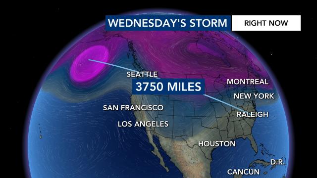
A storm system currently sits over 3,750 miles from Raleigh, specifically located south of Alaska’s Aleutian Islands in the Pacific Ocean as of Saturday morning.

This weather system is expected to head south and move across the United States next week, coinciding with a slight chill lingering in the Eastern U.S.
This scenario opens up the possibility for wintry conditions around Wednesday, February 19, 2025.
Due to less intense cold air compared to January, we may see mixed precipitation levels.

Determining the specifics of precipitation types—whether rain, sleet, or snow—will depend on the storm’s path and intensity.
Possible Outcomes
When forecasting for potential wintry weather several days out, it’s common for initial models to indicate a southern storm track. Over time, this often shifts northwest. I’ve witnessed this trend numerous times during my decade-long forecasting journey in the Mid-Atlantic.
The trajectory of the storm is key.
1. A system moving along the Appalachians would likely produce cold rain in our area.
2. A storm that hugs the coastline could lead to a mix of sleet and freezing rain.
3. If the system stays further offshore, it would increase the probability of snowfall.

With this in mind, I would be surprised to see a major snowstorm, as they are infrequent in North Carolina.
When Will We Have More Information?
Since the storm is currently over the Pacific, accurate sampling for data is limited. However, that will change once it reaches land near Washington State on Sunday night or Monday morning.
Weather balloons will be deployed into the storm, collecting crucial data that will be integrated into our forecasting models, ideally improving clarity and accuracy.