

As severe winds swept through the Washington D.C. area on Sunday, tens of thousands of residents found themselves without electricity. The conditions were so extreme that one of the region’s key bridges was closed due to wind gusts exceeding 55 mph.
The Maryland Transportation Authority announced that the Bay Bridge is currently closed to all traffic. While the Nice-Middleton Bridge has reopened, it remains under wind restrictions.
In Montgomery County, Maryland, numerous trees have fallen, blocking streets and taking down power lines—one incident even involved a tree landing on a home.
Dominion Energy reported over 40,000 power outages, with approximately 20,000 occurring in Fairfax County, where fire officials noted that seven trees have fallen onto houses as of 6 p.m. Meanwhile, PEPCO has also reported over 7,000 customers without power, as more than 5,000 residents in Montgomery County are affected. Additionally, BGE is reporting more than 30,000 outages.
Furthermore, there’s a possibility of late-day thunderstorms, which could add to the challenging weather conditions.
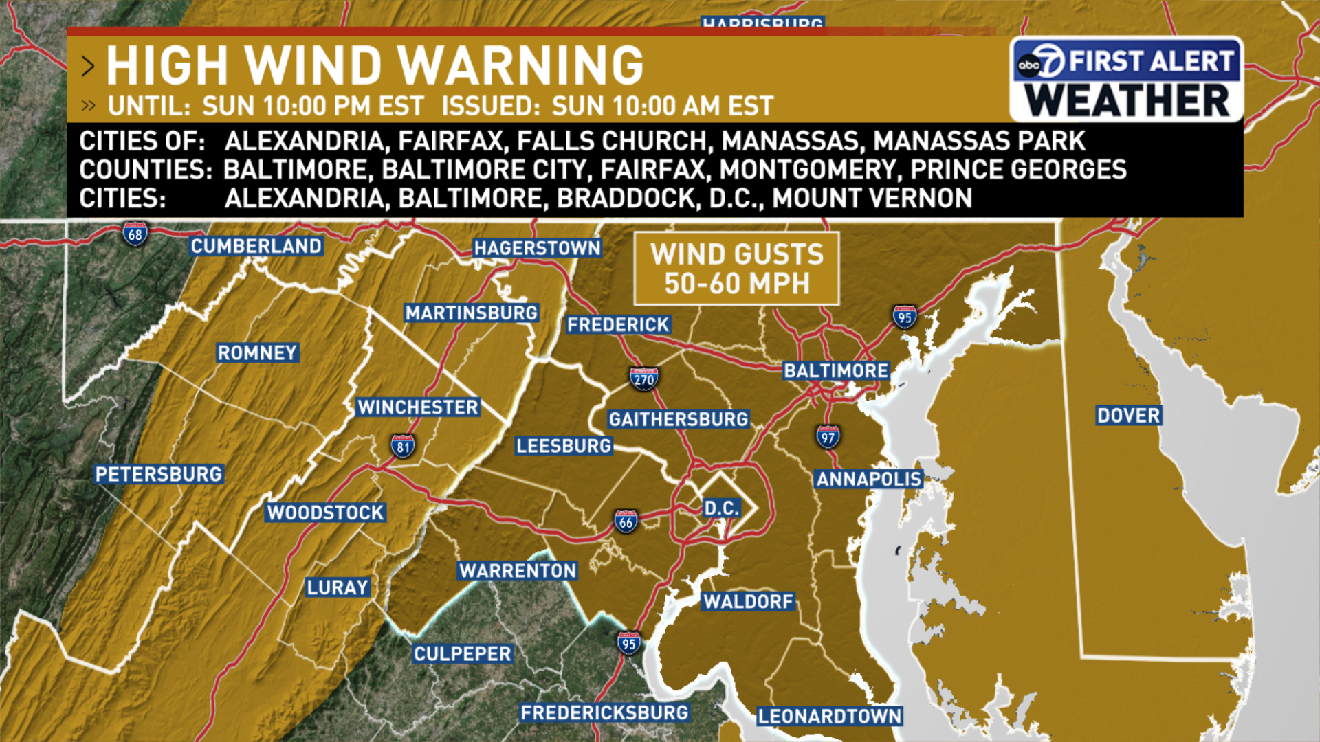
The National Weather Service cautioned that “travel will be challenging, especially for high-profile vehicles.” A high wind warning is in effect until 10 p.m. on Sunday, with sustained winds expected to be between 20 to 30 mph.
While the wind is predicted to calm slightly after midnight, gusts could still reach up to 40 mph, according to meteorologist Evans. Sunday’s temperatures remain mild, hovering in the low 60s.
Senior Meteorologist Veronica Johnson from 7News First Alert explained that forecasting complex storm systems can be difficult. “Days in advance, predicting how much cold air or moisture will enter a system, as well as wind direction and storm intensity, is challenging,” she noted.
She emphasized, “If our weather models were entirely accurate, we would be using them to win the lottery.”
Even though predicting the weather can be uncertain, Monday morning is anticipated to be quite cold, with wind chills dropping to around 20 degrees.
As we look ahead to the upcoming week, all eyes are on midweek as another snowfall is expected from late Wednesday into Thursday.
Evans predicts snow to commence late Wednesday afternoon, with heavy snowfall expected during the evening and into the night.
Bridge Status Updates
Bay Bridge: Completely closed.
Nice Bridge/Middleton: Currently under wind restrictions.
Tydings Bridge: Wind warnings are in effect.
Power Outage Information
The map below details current power outages across Virginia, Maryland, and D.C., updated every ten minutes.
7News First Alert Forecast
SUNDAY EVENING:
Clearing skies; windy
Temperatures: 35-56
Winds: West 20-30 mph; Gusts: 50-60 mph
Conditions will gradually improve, but a High Wind Warning is active until 10 p.m. per the National Weather Service.
SUNDAY NIGHT: WIND ALERT
Windy
Lows: 25-30
Wind Chill: 15-20
Winds: West 15-25 mph; Gusts: West 35-40 mph
Winds are expected to remain strong overnight with gusts nearing 40 mph. Temperatures are likely to drop into the upper 20s by dawn.
MONDAY:
Windy
Highs: 35-40
Wind Chill: 25-30
Winds: Northwest 15-25 mph; Gusts: West 35-40 mph
Strong northwest winds with gusts may reach 40 mph. Highs will be below average, peaking in the upper 30s.
TUESDAY:
Partly Cloudy
Highs: 30-35
Winds: Northwest 10-15 mph
A calm day anticipated before a winter storm moves into the mid-Atlantic region.
WEDNESDAY: WINTER ALERT
Heavy PM Snow
Highs: 26-32
Winds: North 5-10 mph
Monitoring a midweek winter storm that promises measurable snowfall starting in the evening and continuing into the night. Updates on timing and accumulation will be provided.
Ensure to complete your storm preparations on Wednesday morning, as heavy snow is anticipated in the evening hours.
THURSDAY: WINTER ALERT
Morning Snow
Highs: 27-32
Winds: Northwest 10-20 mph; Gusts: 30 mph
Morning snow is expected to conclude by noon, with temperatures remaining at or below freezing, keeping any accumulated snow on the ground.
Current Weather Conditions
Report contributed by WTOP’s Will Vitka.
Stay informed with breaking news and headlines delivered to your inbox by signing up here.
© 2025 WTOP. All Rights Reserved. This site is not intended for users within the European Economic Area.