
Just a month after powerful Santa Ana winds ignited a wildfire across Los Angeles County, residents encountered yet another severe weather event on Thursday. The most significant storm of the season struck the Southland, resulting in mudslides, flooding, and reports of stranded vehicles.
Heavy rainfall caused a flow of mud and water from the hills to cascade onto Pacific Coast Highway in Malibu on Thursday afternoon. The picturesque highway will remain shut down between Chautauqua Boulevard and Carbon Beach Terrace until at least 6 a.m. on Friday, according to the California Department of Transportation.
At approximately 12:25 p.m., firefighters responded to an emergency in Elysian Valley after receiving reports of a small white pickup truck caught in a flood at 3050 N. Coolidge Ave., as per the Los Angeles Fire Department. Shortly thereafter, at 12:40 p.m., crews were dispatched to a similar situation involving a silver SUV partially submerged in fast-moving water near Parthenia Street and Noble Avenue in Panorama City. It was not immediately known if anyone was trapped inside these vehicles.
By mid-afternoon Thursday, rainfall in certain areas approached rates of nearly three-quarters of an inch per hour. Meanwhile, CalTrans crews were diligently clearing debris from roads to mitigate flooding.
At 3:30 p.m., the National Weather Service issued a warning about a band of heavy rain headed for Los Angeles County in the coming hours, indicating the potential for even more intense rainfall, with rates reaching up to an inch per hour.
“Prepare for a rapid increase in rainfall, resulting in heightened road flooding and risks of debris flows from burn scars,” the weather service cautioned.
On Thursday morning, Jude Bell sat in her SUV, protected from the steady rain impacting her red brick home in Altadena, making a checklist of tasks while waiting for a contractor’s arrival.
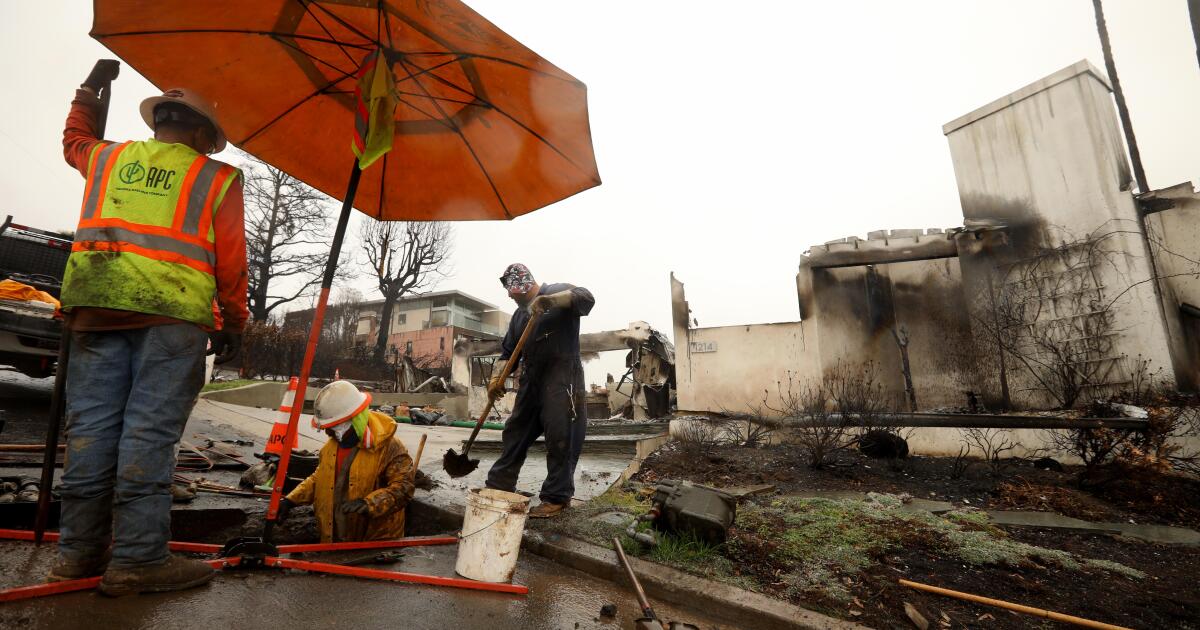
Unlike many homes just a block away, her residence on Alameda Street stood intact following the catastrophic wildfire that swept through the San Gabriel Valley community, causing devastation and loss of life.
Her home suffered damage from the strong Santa Ana winds associated with the blaze, and the interior still carries a smoky odor. A month after the fire, she’s still entangled in discussions with her insurance company about necessary repairs, and she harbors concerns about hazardous substances in the soil.
With all of this, the looming rain felt like just another obstacle. The storm was not her primary concern, even as experts warned of its potential to trigger hazardous debris flows that could further devastate the already struggling community.
“Who knows?” Bell voiced wearily. “The fire wasn’t my main thought, either. I never imagined my house would be damaged by fire.”
Previous atmospheric rivers that brought light rain across Los Angeles County earlier in the month did not lead to significant damage. However, Thursday marked the arrival of the winter’s strongest storm, which threatened to unleash heavy rainfall over fire-damaged areas, prompting evacuations and officials to race to safeguard vulnerable neighborhoods.
In the San Gabriel Valley, where the Eaton fire wreaked havoc—destroying over 9,400 structures, including numerous homes, and claiming 17 lives—a state report remarked on the high likelihood of heavy rain triggering significant flooding and debris flows.
On the Westside, where the Palisades fire impacted hillside communities reaching the Pacific Ocean, officials also braced for potential rockslides, debris flows, and flooding.
“If these heavy rainfall areas settle over burn scars—such as the Palisades, Eaton, and other affected areas throughout greater Los Angeles—there’s a strong possibility of severe debris flows, in addition to mudslides and rockslides,” stated Ariel Cohen, meteorologist in charge of the National Weather Service Los Angeles/Oxnard office, during a news conference on Thursday.
“Again, the situation remains uncertain—far from guaranteed right now—but it’s vital that everyone stays alert as we progress through the afternoon and evening,” Cohen added.

A significant debris flow on February 6, 2010, inundated over 40 homes in La Cañada Flintridge’s northernmost neighborhood with mud, boulders, and damaged vehicles. In the image, a woman evacuates her home during that incident.
(Raul Roa / Los Angeles Times)
Forecasters alert that conditions could change quickly with little notice, suggesting residents park away from trees, keep electronic devices charged, and be ready to evacuate swiftly if necessary.
Customers at Ace Hardware in Altadena have been flocking in to purchase essential items like tarps and sandbags to safeguard their damaged properties from the anticipated weather.
Many have been visibly distressed, according to cashier Paola Vargas, 25.
“They’re frightened; we’re all a little scared,” admitted Vargas, who also resides in Altadena. “First, we had to evacuate due to the fire, and now we’re preparing for a potential flood?”
Though her home survived the fire, it was contaminated by smoke, prompting her family to discard many belongings as a result.
“I doubt things will ever feel the same again,” she lamented. “My house is still standing, but with so many neighbors’ homes gone, it feels empty. The atmosphere is different, strangely quiet.”
Throughout Los Angeles County, sheriff’s deputies and police officers visited residents in high-risk zones, urging them to consider evacuating or at least preparing to leave promptly.
Mandatory evacuation orders were issued for 106 residences in Pacific Palisades, nine homes in the Sunset fire area, and four homes in the Hurst fire zone, stated Los Angeles Police Chief Jim McDonnell.
“These are mandatory evacuations, not mere warnings,” he emphasized. “Residents must leave for their safety. We recognize that evacuations are challenging, but we aim to prioritize community safety.”
In jurisdictions managed by the L.A. County Sheriff’s Department—Malibu, Altadena, San Dimas, and Palmdale—98 homes were under mandatory evacuation orders, according to spokesperson Nicole Nishida.
Evacuation warnings were also announced in several burned areas, including Brentwood, Sunset Mesa, Hollywood, Hollywood Hills West, Sylmar, Calabasas, Kinneloa Mesa, Arcadia, Sierra Madre, and the San Gabriel Mountains, encompassing Mount Baldy Village and Wrightwood.
As of Thursday afternoon, robust thunderstorms were affecting Santa Barbara and San Luis Obispo counties, with forecasters predicting wind gusts of up to 55 mph along with pea-sized hail.
Further south in Orange County, continuous rainfall led to evacuations, and Knott’s Berry Farm was shut down.
In areas previously scorched by the Airport fire above Trabuco Canyon in September, a mandatory evacuation order was implemented for the RC Airport, fire station, campground/park, school, Bell Canyon, and Hot Springs Canyon.
Recently burned areas are at heightened risk for landslides during heavy rainfall, as the soil is no longer stabilized by flourishing vegetation. The heat from fires compromises the soil’s ability to absorb water, leaving hillsides more susceptible to erosion. This can lead to cascades of mud, rocks, and fallen branches surging at speeds of up to 35 mph, posing threats to homes and lives.
In the aftermath of the 2009 Station fire, which was the largest wildfire in L.A. County history spanning 160,557 acres, a significant debris flow on February 6, 2010, devastated over 40 homes in La Cañada Flintridge’s northern neighborhoods.
The cause was an intense series of rain showers that developed over the burned mountains, exacerbated by a ten-ton boulder blocking the Mullally Canyon debris basin, designed to capture run-off from the slopes. In response, officials later constructed a $1.5 million drain pipe to redirect rainwater from the basin and improved the area’s catch basins’ storage capacity.

Animated infographic showing how a debris flow works
Although all recent burn areas are under scrutiny, forecasts indicate that the Eaton fire, Palisades fire, and Bridge fire burn scars face the highest risk of damage during this storm.
Data compiled by the U.S. Geological Survey reveals that a rainstorm producing peak rainfall of 1.57 inches per hour over 15 minutes could have an 80% to 100% chance of causing debris flows across much of the Eaton fire zone.
In the Palisades, a storm that releases 0.94 inch of rain per hour could lead to a 60% to 80% likelihood of debris flows along areas of Tuna Canyon Park, Temescal Canyon, and above the Pacific Palisades. Portions of the hillsides above Malibu and within the Mandeville Canyon area are at even greater risk, according to USGS data.
The Eaton burn scar could experience peak rainfall rates of 0.85 inches per hour, while the Palisades burn scar could witness rates of 0.79 inches per hour during the storm. Experts emphasize that any rain falling at half an inch per hour or more could trigger debris flows in recently burned areas.
However, the majority of the storm’s peak intensity is predicted to deliver more modest rainfall rates of a quarter to half an inch per hour, according to Ryan Kittell, a meteorologist with the National Weather Service.
It is the brief, intense bursts of heavy rain that may pose the most significant challenges.
“We could realistically see that occurring anywhere,” Kittell noted. “It won’t necessarily be widespread; it all depends on where those heavier storm cells materialize.”
The storm is anticipated to leave the region by Friday, potentially marking the start of another extended period of dry weather for the remainder of February.

Burn scars from the Eaton, Palisades, Franklin, and Bridge fires are at considerable risk of landslides due to high peak rainfall rates.
(National Weather Service)
Here’s what you need to know regarding timing, evacuation orders, and other essential information:
Storm Timing
Here’s the expected timing for various counties regarding the storm’s peak effects; timing may differ by a few hours:
San Luis Obispo County: 8 a.m. to 2 p.m.
Santa Barbara County: 10 a.m. to 5 p.m.
Ventura County: 2 to 8 p.m.
Los Angeles County: 3 to 10 p.m.
Orange County and Inland Empire: 5 to 10 p.m.
San Diego County: 8 p.m. to 2 a.m.
The latest forecasts suggest peak rainfall rates could reach half an inch to an inch per hour, with localized areas potentially receiving up to 1.2 inches per hour in Los Angeles, Ventura, Santa Barbara, and San Luis Obispo counties.
In Orange and San Diego counties, as well as the Inland Empire, anticipated rates are between 0.3 to 0.5 inches per hour for coastal and valley areas. Mountain coastal slopes may experience rates of 0.5 to 0.75 inches per hour, with isolated pockets totaling up to an inch per hour.

(National Weather Service)
Evacuation Updates
Evacuation maps are available here and here.
Los Angeles County:
Pacific Palisades: 106 homes were placed under mandatory evacuation orders, and access to the area will be restricted to residents only from 7 a.m. Thursday to 2 p.m. Friday. Contractors with passes will be denied entry. Evacuation alerts have been issued for the Getty Villa area, portions of Highlands near the burned zones, sections along Bienveneda Avenue, northern parts of Temescal Canyon Road, Marinette Road’s northern edge, and the area surrounding Will Rogers State Park Road, including Villa Woods Drive and Villa Grove Drive.
Brentwood: A warning was issued for Mandeville Canyon Road north of Tanners Road.
Malibu: Evacuation alerts were made for approximately the eastern half of Malibu, from the city’s eastern edge to the intersection of Pacific Coast Highway and Malibu Road, near Bayshore Drive. This alert also includes the Malibu Civic Center as well as Pepperdine University, which is transitioning to remote classes on Thursday. The university clarified that consulting engineers assessed the Malibu campus as having a “low risk of challenges from debris flow,” and a mandatory evacuation for Pepperdine is deemed “highly unlikely.” Malibu’s public schools are closed on Thursday.
Sunset Mesa: This unincorporated area between Malibu and Pacific Palisades just north of Pacific Coast Highway is under an evacuation warning.
Hollywood and Hollywood Hills West: Nine homes are currently under mandatory evacuation orders. Warnings are also in effect around the Sunset fire zone, particularly near Runyon Canyon, including blocks on North Vista Street and North Curson Avenue.
Sylmar: Four homes are under a mandated evacuation order, with warnings in place along the western edge of Oakridge Mobile Home Park.
Sierra Madre: Northern sections are under an evacuation order.
Calabasas: Warnings are active in the Malibu Canyon and Alizia Canyon neighborhoods.
Altadena: Warnings have been issued for northern Altadena areas adjacent to the San Gabriel Mountains.
Kinneloa Mesa: This neighborhood is currently under an evacuation alert.
Pasadena: A warning is in effect for a northeastern area of the city, including the northern sections of Hastings Ranch Road and Park Vista Drive.
San Gabriel Mountains: Warnings span areas between East Fork Road and Shoemaker Canyon Road along the San Gabriel River.
Arcadia: The northern section of the city is under an evacuation alert.
Ventura County:
Unincorporated Camarillo: Evacuation warnings have been issued for residents in the unincorporated neighborhoods north of Camarillo’s limits.
Orange County
Officials in Orange County issued a mandatory evacuation order for regions in Trabuco Creek, including the RC Airport, fire station, campground/park, school, Bell Canyon, and Hot Springs Canyon due to the threat of debris flows linked to the Airport fire burn scar.
Voluntary evacuation alerts are also present for Long Canyon and Modjeska Canyon.
San Bernardino County
Evacuation warnings have been issued for the unincorporated communities of Mount Baldy Village and Wrightwood, along with some northern and eastern neighborhoods of the city of Highland.
Santa Barbara County
The county has issued an evacuation order for areas in and around the Lake fire burn zone in the mountains north of Los Olivos, while a broader evacuation warning affects a wider area.
Flood Watches
The National Weather Service has issued flood watches across extensive regions of Southern California. Here’s the schedule for each:
Los Angeles and Ventura counties: 10 a.m. to 10 p.m. Thursday for the burn scars, with a warning about “high risk for at least shallow debris flows affecting roads and moderate risk for damaging debris flows threatening structures.”
Santa Barbara County: 10 a.m. to 7 p.m. for the Lake burn scar, where a “moderate risk for damaging debris flows threatening structures” is noted.
San Luis Obispo County: 4 a.m. to 2 p.m. for all of the county, facing a high risk of significant road flooding and closures, along with a moderate risk of creek flooding, notably for San Simeon Creek and Santa Rosa Creek, which flows to the ocean through Cambria.
Orange, San Diego counties, and the Inland Empire: Effective from 10 a.m. through late Thursday night, there’s a risk of excessive runoff leading to flooding of rivers, creeks, streams, and other low-lying areas. Flooding may occur in poorly drained urban regions, with possible debris flows in areas below recent burn scars, according to the weather service.