
Eleven years ago, discussing a storm that was still four to five days away was uncommon in our industry. However, the landscape of weather reporting has significantly evolved since then.
Nowadays, we often see storm predictions popping up on our mobile apps or social media, raising questions about their accuracy.
In light of this, it’s essential for us to provide updates, rather than remaining silent.
With that context in mind, let’s summarize the situation for you.
Summary
Yes. There is a heightened possibility of a winter storm affecting North Carolina from Wednesday, February 19, through early Thursday, February 20.
No. We cannot predict exact snowfall totals for your area at this stage.
Continue reading for our insights on the storm’s progress, potential outcomes, and when we can expect more accurate information.
Current Monitoring
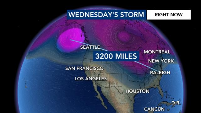
As of Sunday morning, we are tracking a storm system that is approximately 3,200 miles from Raleigh, currently located south of Alaska’s Aleutian Islands over the Pacific.

This system is projected to move southward and traverse across the U.S. next week, while the Eastern U.S. remains under relatively cool conditions.
This meteorological setup increases the likelihood of a significant winter storm around Wednesday, February 19, 2025.
Because the cold air is not as deep as it was last January, we may experience a mix of precipitation types.

The precise division between rain and snow will depend on the storm’s path and intensity. Therefore, it’s prudent to prepare for potential disruptions in travel for Wednesday and Thursday.
Potential Outcomes
When forecasting wintry conditions days in advance, the projected storm track often begins farther south. Typically, as the event approaches, the forecast shifts northwest. I’ve observed this pattern multiple times throughout my forecasting career in the Mid-Atlantic region.
The track of the storm is pivotal:
1. If the system moves along the Appalachian Mountains, it is likely to result in a cold rain.
2. A coastal path could lead to sleet and freezing rain.
3. A more robust system positioned offshore would increase the likelihood of snow accumulation.

Considering these factors, I would be surprised if we experienced a full-blown snowstorm anywhere from the Triangle area southward, as such events are quite rare in North Carolina.
When Will We Have More Information?
Since the storm is currently over the Pacific Ocean, collecting data on it is challenging. However, this situation will improve when it reaches land near Washington State late Sunday night or early Monday morning.
Weather balloons will be deployed to gather essential data, which will then be integrated into forecasting models. This process should enhance our understanding and accuracy as the event progresses.